
OSM PostgreSQL Server
Uses Flask to serve the web-based map interface and handle server-to-client communication
Provides a web-based map viewer interface for visualizing OpenStreetMap data
Enables querying and visualization of map data, with tools for map control including adding markers, polygons, setting views, and getting current view
Offers a query interface for OpenStreetMap data stored in PostgreSQL/PostGIS databases
Click on "Install Server".
Wait a few minutes for the server to deploy. Once ready, it will show a "Started" state.
In the chat, type
@followed by the MCP server name and your instructions, e.g., "@OSM PostgreSQL Servershow me all coffee shops within 1km of Times Square"
That's it! The server will respond to your query, and you can continue using it as needed.
Here is a step-by-step guide with screenshots.
MCP-OSM: OpenStreetMap Integration for MCP
This package provides OpenStreetMap integration for MCP, allowing users to query and visualize map data through an MCP interface.
Features
Web-based map viewer using Leaflet and OpenStreetMap
Server-to-client communication via Server-Sent Events (SSE)
MCP tools for map control (adding markers, polygons, setting view, getting view)
PostgreSQL/PostGIS query interface for OpenStreetMap data
Related MCP server: OSP Marketing Tools MCP Server
Installation
This is my claude_desktop_config.json:
{
"mcpServers": {
"OSM PostgreSQL Server": {
"command": "/Users/wiseman/.local/bin/uv",
"args": [
"run",
"--env-file",
".env",
"--with",
"mcp[cli]",
"--with",
"psycopg2",
"--with-editable",
"/Users/wiseman/src/mcp-osm",
"--directory",
"/Users/wiseman/src/mcp-osm",
"mcp",
"run",
"mcp.py"
]
}
}
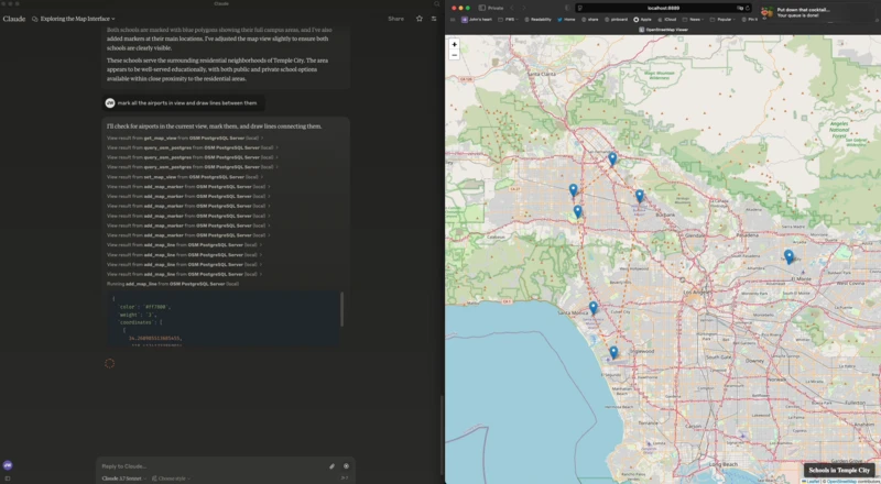
}When the MCP server starts it also starts a web server at http://localhost:8889/ that has the map interface.
Environment Variables
The following environment variables can be used to configure the MCP:
FLASK_HOST- Host for the Flask server (default: 127.0.0.1)FLASK_PORT- Port for the Flask server (default: 8889)PGHOST- PostgreSQL host (default: localhost)PGPORT- PostgreSQL port (default: 5432)PGDB- PostgreSQL database name (default: osm)PGUSER- PostgreSQL username (default: postgres)PGPASSWORD- PostgreSQL password (default: postgres)
MCP Tools
The following MCP tools are available:
get_map_view- Get the current map viewset_map_view- Set the map view to specific coordinates or boundsset_map_title- Set the title displayed at the bottom right of the mapadd_map_marker- Add a marker at specific coordinatesadd_map_line- Add a line defined by a set of coordinatesadd_map_polygon- Add a polygon defined by a set of coordinatesquery_osm_postgres- Execute a SQL query against the OpenStreetMap database
This server cannot be installed
Resources
Unclaimed servers have limited discoverability.
Looking for Admin?
If you are the server author, to access and configure the admin panel.
Latest Blog Posts
MCP directory API
We provide all the information about MCP servers via our MCP API.
curl -X GET 'https://glama.ai/api/mcp/v1/servers/wiseman/osm-mcp'
If you have feedback or need assistance with the MCP directory API, please join our Discord server