
mapbox-mcp-server
The Mapbox MCP Server provides navigation, matrix calculations, and geocoding services through the Mapbox API:
Navigation: Get directions between coordinates (
mapbox_directions) or places by name (mapbox_directions_by_places) for driving, walking, cycling, or driving with traffic.Matrix Calculations: Calculate travel time and distance matrices between coordinates or places with customizable options.
Geocoding: Search for places and convert addresses to coordinates with support for fuzzy matching, language preferences, and result filtering.
Error Handling: Comprehensive validation and error management for API interactions.
Provides navigation and geocoding capabilities through the Mapbox API, including routing between coordinates or place names, calculating travel time and distance matrices, and converting place names to coordinates.
Click on "Install Server".
Wait a few minutes for the server to deploy. Once ready, it will show a "Started" state.
In the chat, type
@followed by the MCP server name and your instructions, e.g., "@mapbox-mcp-serverget directions from Central Park to Times Square"
That's it! The server will respond to your query, and you can continue using it as needed.
Here is a step-by-step guide with screenshots.
Mapbox MCP Server
MCP Server for the Mapbox API.
Features
Navigation Tools
mapbox_directionsGet directions between coordinates
Inputs:
coordinates({latitude: number, longitude: number}[])profile(optional): "driving-traffic", "driving", "walking", "cycling"
Returns: route details with steps, distance, duration
mapbox_directions_by_placesGet directions between places using their names
Inputs:
places(string[]): Array of place namesprofile(optional): "driving-traffic", "driving", "walking", "cycling"language(optional): Two-letter language code (e.g., "zh", "en")
Returns:
Geocoding results for each place
Route details with steps, distance, duration
Any errors that occurred during processing
mapbox_matrixCalculate travel time and distance matrices between coordinates
Inputs:
coordinates({latitude: number, longitude: number}[])profile(optional): "driving", "walking", "cycling"annotations(optional): "duration", "distance", "duration,distance"sources(optional): Indices of source coordinatesdestinations(optional): Indices of destination coordinates
Returns: Matrix of durations and/or distances between points
mapbox_matrix_by_placesCalculate travel time and distance matrices between places using their names
Inputs:
places(string[]): Array of place names (2-25 places)profile(optional): "driving", "walking", "cycling"annotations(optional): "duration", "distance", "duration,distance"language(optional): Two-letter language codesources(optional): Indices of source placesdestinations(optional): Indices of destination places
Returns:
Geocoding results for each place
Matrix of durations and/or distances
Any errors that occurred during processing
Search Tools
mapbox_geocodingSearch for places and convert addresses into coordinates
Inputs:
searchText(string): The place or address to search forlimit(optional): Maximum number of results (1-10)types(optional): Filter by place types (country, region, place, etc.)language(optional): Two-letter language codefuzzyMatch(optional): Enable/disable fuzzy matching
Returns: Detailed location information including coordinates and properties
Related MCP server: MCP Server
Claude Desktop Integration
Add this configuration to your Claude Desktop config file (typically located at ~/Library/Application Support/Claude/claude_desktop_config.json):
{
  "mcpServers": {
    "mapbox-mcp-server": {
      "command": "node",
      "args": ["/absolute/path/to/mapbox-mcp-server/build/index.js"],
      "env": {
        "MAPBOX_ACCESS_TOKEN": "your-api-key"
      }
    }
  }
}
Setup
Prerequisites
Node.js 16 or higher
TypeScript 4.5 or higher
A valid Mapbox API key
API Key
Get a Mapbox API key by following the instructions here.
Set your API key as an environment variable:
export MAPBOX_ACCESS_TOKEN=your_api_key_hereRate Limits
Directions API: 300 requests per minute
Matrix API:
60 requests per minute for driving/walking/cycling
30 requests per minute for driving-traffic
Geocoding API: 600 requests per minute
Deployment
Structure
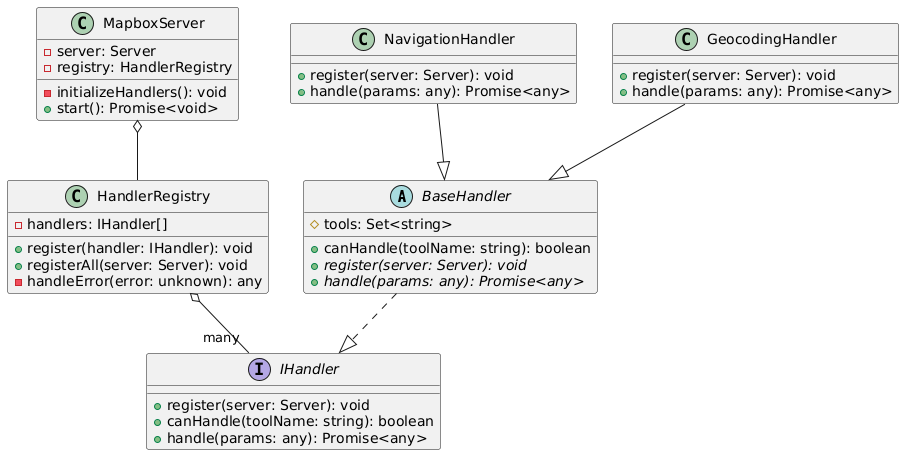
In mapbox-mcp-server, we use the following structure to manage the server's handlers:
src/server/handlers/base.ts: Base class for all handlerssrc/server/registry.ts: Registry for all handlerssrc/server/main.ts: Main entry point for the server
Each feature module follows this structure:
src/
├── types/          # Type definitions
├── schemas/        # Zod schemas for validation
├── tools/
│   ├── definitions/  # Tool definitions
│   └── handlers/     # Tool implementations
└── server/
    └── handlers/     # Handler classes
Class Diagram:
Process Diagram:

Error Handling
All tools implement comprehensive error handling:
Input validation errors
API request failures
Rate limit errors
Service-specific errors (e.g., no routes found, invalid coordinates)
License
This MCP server is licensed under the MIT License. This means you are free to use, modify, and distribute the software, subject to the terms and conditions of the MIT License. For more details, please see the LICENSE file in the project repository.
Resources
Unclaimed servers have limited discoverability.
Looking for Admin?
If you are the server author, to access and configure the admin panel.
Latest Blog Posts
MCP directory API
We provide all the information about MCP servers via our MCP API.
curl -X GET 'https://glama.ai/api/mcp/v1/servers/AidenYangX/mapbox-mcp-server'
If you have feedback or need assistance with the MCP directory API, please join our Discord server