OpenStreetMap MCP Server
The OpenStreetMap MCP Server enhances LLM capabilities by providing location-based services and geospatial data processing for applications. With this server, you can:
Geocode addresses: Convert text descriptions into geographic coordinates with metadata
Reverse geocode: Transform coordinates into human-readable addresses
Find nearby places: Discover points of interest around specific locations
Get route directions: Calculate turn-by-turn navigation for walking, biking, or driving
Search by category: Find specific types of places within defined areas
Suggest meeting points: Determine optimal meeting locations for multiple people
Explore areas: Analyze neighborhoods for amenities and points of interest
Find schools: Locate educational institutions with filters
Analyze commutes: Evaluate transportation options between locations
Find EV charging stations: Locate charging infrastructure with connector and power filters
Assess neighborhood livability: Evaluate quality of life factors
Find parking facilities: Locate parking options with capacity and fee details
Supports debugging via the MCP Inspector which can be launched using npm to monitor and troubleshoot the MCP server communications.
Provides geospatial tools for interacting with OpenStreetMap data, including geocoding, reverse geocoding, finding nearby points of interest, route directions, location search by category, meeting point optimization, area exploration, and neighborhood analysis.
Enables publishing and distribution of the MCP server package through PyPI, allowing users to easily install the server.
Click on "Deploy Server".
Wait a few minutes for the server to deploy. Once ready, it will show a "Started" state.
In the chat, type
@followed by the MCP server name and your instructions, e.g., "@OpenStreetMap MCP Server find the best meeting point for friends coming from downtown, midtown, and uptown"
That's it! The server will respond to your query, and you can continue using it as needed.
Here is a step-by-step guide with screenshots.
OpenStreetMap (OSM) MCP Server
An OpenStreetMap MCP server implementation that enhances LLM capabilities with location-based services and geospatial data.
Demo
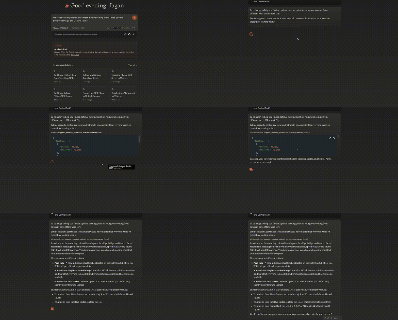
Meeting Point Optimization
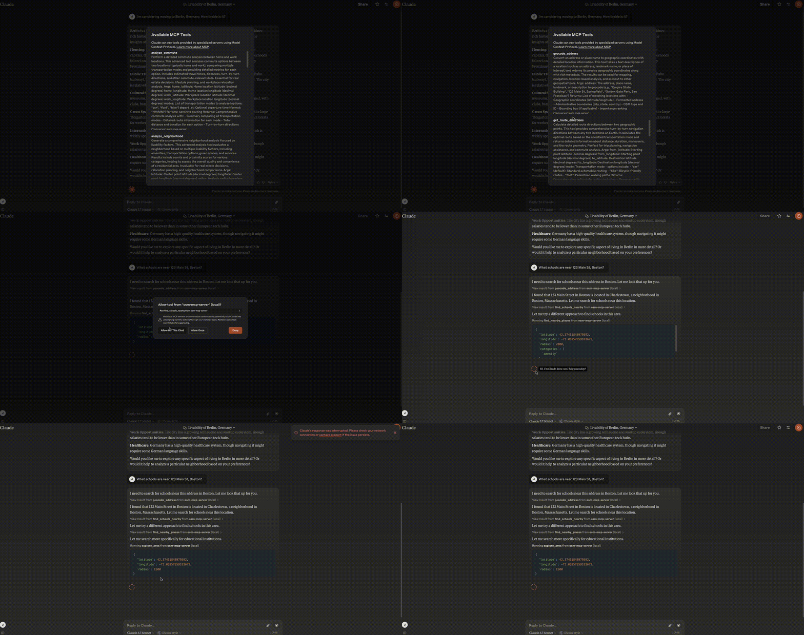
Neighborhood Analysis
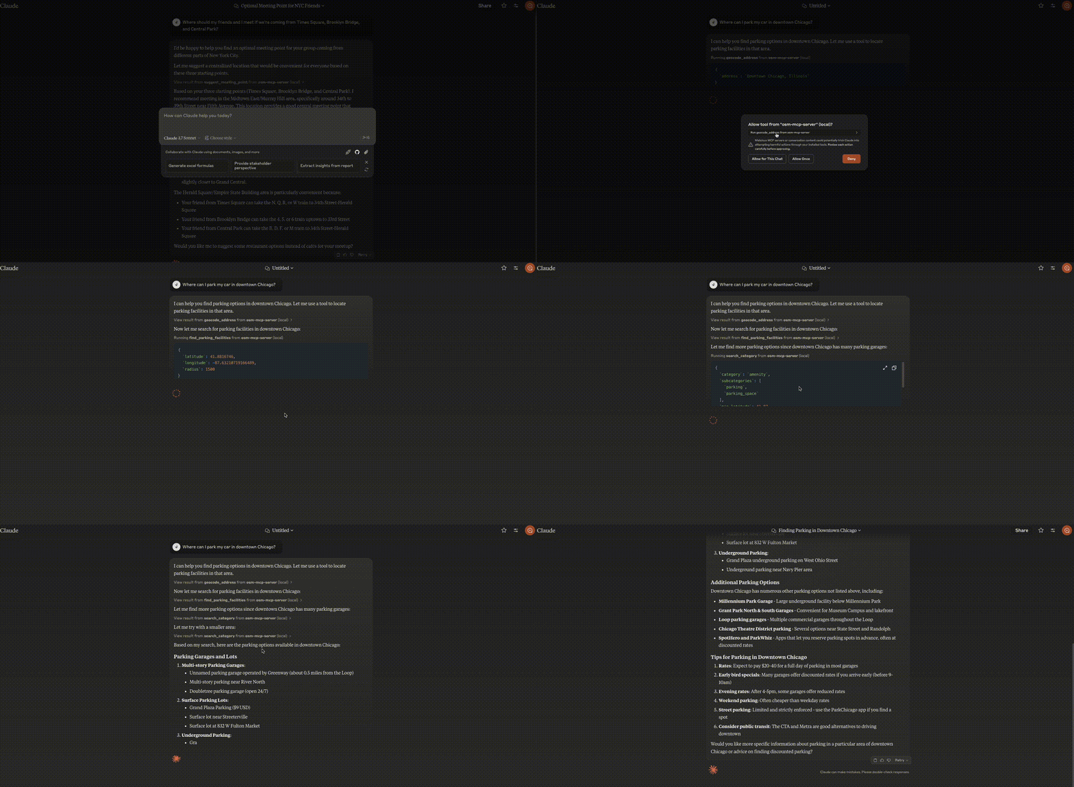
Parking Search
Related MCP server: Mapbox MCP Server
Installation
In MCP Hosts like Claude Desktop, Cursor, Windsurf, etc.
osm-mcp-server: The main server, available for public use."mcpServers": { "osm-mcp-server": { "command": "uvx", "args": [ "osm-mcp-server" ] } }
Features
This server provides LLMs with tools to interact with OpenStreetMap data, enabling location-based applications to:
Geocode addresses and place names to coordinates
Reverse geocode coordinates to addresses
Find nearby points of interest
Get route directions between locations
Search for places by category within a bounding box
Suggest optimal meeting points for multiple people
Explore areas and get comprehensive location information
Find schools and educational institutions near a location
Analyze commute options between home and work
Locate EV charging stations with connector and power filtering
Perform neighborhood livability analysis for real estate
Find parking facilities with availability and fee information
Components
Resources
The server implements location-based resources:
location://place/{query}: Get information about places by name or addresslocation://map/{style}/{z}/{x}/{y}: Get styled map tiles at specified coordinates
Tools
The server implements several geospatial tools:
geocode_address: Convert text to geographic coordinatesreverse_geocode: Convert coordinates to human-readable addressesfind_nearby_places: Discover points of interest near a locationget_route_directions: Get turn-by-turn directions between locationssearch_category: Find places of specific categories in an areasuggest_meeting_point: Find optimal meeting spots for multiple peopleexplore_area: Get comprehensive data about a neighborhoodfind_schools_nearby: Locate educational institutions near a specific locationanalyze_commute: Compare transportation options between home and workfind_ev_charging_stations: Locate EV charging infrastructure with filteringanalyze_neighborhood: Evaluate neighborhood livability for real estatefind_parking_facilities: Locate parking options near a destination
Local Testing
Running the Server
To run the server locally:
Install the package in development mode:
pip install -e .Start the server:
osm-mcp-serverThe server will start and listen for MCP requests on the standard input/output.
Testing with Example Clients
The repository includes two example clients in the examples/ directory:
Basic Client Example
client.py demonstrates basic usage of the OSM MCP server:
python examples/client.pyThis will:
Connect to the locally running server
Get information about San Francisco
Search for restaurants in the area
Retrieve comprehensive map data with progress tracking
LLM Integration Example
llm_client.py provides a helper class designed for LLM integration:
python examples/llm_client.pyThis example shows how an LLM can use the Location Assistant to:
Get location information from text queries
Find nearby points of interest
Get directions between locations
Find optimal meeting points
Explore neighborhoods
Writing Your Own Client
To create your own client:
Import the MCP client:
from mcp.client import ClientInitialize the client with your server URL:
client = Client("http://localhost:8000")Invoke tools or access resources:
# Example: Geocode an address
results = await client.invoke_tool("geocode_address", {"address": "New York City"})Claude Desktop config for local server
On MacOS: ~/Library/Application\ Support/Claude/claude_desktop_config.json
On Windows: %APPDATA%/Claude/claude_desktop_config.json
"mcpServers": {
"osm-mcp-server": {
"command": "uv",
"args": [
"--directory",
"/path/to/osm-mcp-server",
"run",
"osm-mcp-server"
]
}
}Development
Building and Publishing
To prepare the package for distribution:
Sync dependencies and update lockfile:
uv syncBuild package distributions:
uv buildThis will create source and wheel distributions in the dist/ directory.
Publish to PyPI:
uv publishNote: You'll need to set PyPI credentials via environment variables or command flags.
Debugging
Since MCP servers run over stdio, debugging can be challenging. For the best debugging experience, we strongly recommend using the MCP Inspector.
You can launch the MCP Inspector via npm with this command:
npx @modelcontextprotocol/inspector uv --directory /path/to/osm-mcp-server run osm-mcp-serverUpon launching, the Inspector will display a URL that you can access in your browser to begin debugging.
Available Tools
12 toolsanalyze_commuteA
Perform a detailed commute analysis between home and work locations.
This advanced tool analyzes commute options between two locations (typically home and work), comparing multiple transportation modes and providing detailed metrics for each option. Includes estimated travel times, distances, turn-by-turn directions, and other commute-relevant data. Essential for real estate decisions, lifestyle planning, and workplace relocation analysis.
Args: home_latitude: Home location latitude (decimal degrees) home_longitude: Home location longitude (decimal degrees) work_latitude: Workplace location latitude (decimal degrees) work_longitude: Workplace location longitude (decimal degrees) modes: List of transportation modes to analyze (options: "car", "foot", "bike") depart_at: Optional departure time (format: "HH:MM") for time-sensitive routing
Returns: Comprehensive commute analysis with: - Summary comparing all transportation modes - Detailed route information for each mode - Total distance and duration for each option - Turn-by-turn directions
Inputs: home_latitude (required), home_longitude (required), work_latitude (required), work_longitude (required), +2 more.
analyze_neighborhoodA
Generate a comprehensive neighborhood analysis focused on livability factors.
This advanced analysis tool evaluates a neighborhood based on multiple livability factors, including amenities, transportation options, green spaces, and services. Results include counts and proximity scores for various categories, helping to assess the overall quality and convenience of a residential area. Invaluable for real estate decisions, relocation planning, and neighborhood comparisons.
Args: latitude: Center point latitude (decimal degrees) longitude: Center point longitude (decimal degrees) radius: Analysis radius in meters (defaults to 1000m/1km)
Returns: Comprehensive neighborhood profile including: - Overall neighborhood score - Walkability assessment - Public transportation access - Nearby amenities (shops, restaurants, services) - Green spaces and recreation - Education and healthcare facilities - Detailed counts and distance metrics for each category
Inputs: latitude (required), longitude (required), radius.
explore_areaA
Generate a comprehensive profile of an area including all amenities and features.
This powerful analysis tool creates a detailed overview of a neighborhood or area by identifying and categorizing all geographic features, amenities, and points of interest. Results are organized by category for easy analysis. Excellent for neighborhood research, area comparisons, and location-based decision making.
Args: latitude: Center point latitude (decimal degrees) longitude: Center point longitude (decimal degrees) radius: Search radius in meters (defaults to 500m)
Returns: In-depth area profile including: - Address and location context - Total feature count - Features organized by category and subcategory - Each feature includes name, coordinates, and detailed metadata
Inputs: latitude (required), longitude (required), radius.
find_ev_charging_stationsA
Locate electric vehicle charging stations near a specific location.
This specialized search tool identifies EV charging infrastructure within a specified distance from a location. Results can be filtered by connector type (Tesla, CCS, CHAdeMO, etc.) and minimum power delivery. Essential for EV owners planning trips or evaluating potential charging stops.
Args: latitude: Center point latitude (decimal degrees) longitude: Center point longitude (decimal degrees) radius: Search radius in meters (defaults to 5000m/5km) connector_types: Optional list of specific connector types to filter by (e.g., ["type2", "ccs", "tesla"]) min_power: Minimum charging power in kW
Returns: List of charging stations with: - Location name and operator - Available connector types - Charging speeds - Number of charging points - Access restrictions - Other relevant metadata
Inputs: latitude (required), longitude (required), radius, connector_types, +1 more.
find_nearby_placesA
Discover points of interest and amenities near a specific location.
This tool performs a comprehensive search around a geographic point to identify nearby establishments, amenities, and points of interest. Results are organized by category and subcategory, making it easy to find specific types of places. Essential for location-based recommendations, neighborhood analysis, and proximity-based decision making.
Args: latitude: Center point latitude (decimal degrees) longitude: Center point longitude (decimal degrees) radius: Search radius in meters (defaults to 1000m/1km) categories: List of OSM categories to search for (e.g., ["amenity", "shop", "tourism"]). If omitted, searches common categories. limit: Maximum number of total results to return
Returns: Structured dictionary containing: - Original query parameters - Total count of places found - Results grouped by category and subcategory - Each place includes name, coordinates, and associated tags
Inputs: latitude (required), longitude (required), radius, categories, +1 more.
find_parking_facilitiesA
Locate parking facilities near a specific location.
This tool finds parking options (lots, garages, street parking) near a specified location. Results can be filtered by parking type and include capacity information where available. Useful for trip planning, city navigation, and evaluating parking availability in urban areas.
Args: latitude: Center point latitude (decimal degrees) longitude: Center point longitude (decimal degrees) radius: Search radius in meters (defaults to 1000m/1km) parking_type: Optional filter for specific types of parking facilities ("surface", "underground", "multi-storey", etc.)
Returns: List of parking facilities with: - Name and type - Capacity information if available - Fee structure if available - Access restrictions - Distance from search point
Inputs: latitude (required), longitude (required), radius, parking_type.
find_schools_nearbyA
Locate educational institutions near a specific location, filtered by education level.
This specialized search tool identifies schools, colleges, and other educational institutions within a specified distance from a location. Results can be filtered by education level (elementary, middle, high school, university, etc.). Essential for families evaluating neighborhoods or real estate purchases with education considerations.
Args: latitude: Center point latitude (decimal degrees) longitude: Center point longitude (decimal degrees) radius: Search radius in meters (defaults to 2000m/2km) education_levels: Optional list of specific education levels to filter by (e.g., ["elementary", "secondary", "university"])
Returns: List of educational institutions with: - Name and type - Distance from search point - Education levels offered - Contact information if available - Other relevant metadata
Inputs: latitude (required), longitude (required), radius, education_levels.
geocode_addressA
Convert an address or place name to geographic coordinates with detailed location information.
This tool takes a text description of a location (such as an address, landmark name, or place of interest) and returns its precise geographic coordinates along with rich metadata. The results can be used for mapping, navigation, location-based analysis, and as input to other geospatial tools.
Args: address: The address, place name, landmark, or description to geocode (e.g., "Empire State Building", "123 Main St, Springfield", "Golden Gate Park, San Francisco")
Returns: List of matching locations with: - Geographic coordinates (latitude/longitude) - Formatted address - Administrative boundaries (city, state, country) - OSM type and ID - Bounding box (if applicable) - Importance ranking
Inputs: address (required).
get_route_directionsA
Calculate detailed route directions between two geographic points.
This tool provides comprehensive routing information between two locations using OpenStreetMap/OSRM. The output can be minimized using the steps, overview, and annotations parameters to reduce the response size.
Args: from_latitude: Starting point latitude (decimal degrees) from_longitude: Starting point longitude (decimal degrees) to_latitude: Destination latitude (decimal degrees) to_longitude: Destination longitude (decimal degrees) ctx: Context (provided internally by MCP) mode: Transportation mode ("car", "bike", "foot") steps: Turn-by-turn instructions (True/False, Default: False) overview: Geometry output ("full", "simplified", "false"; Default: "simplified") annotations: Additional segment info (True/False, Default: False)
Returns: Dictionary with routing information (summary, directions, geometry, waypoints)
Example: { "from_latitude": 51.3334193, "from_longitude": 9.4540423, "to_latitude": 51.3295516, "to_longitude": 9.4576721, "mode": "car", "steps": false, "overview": "simplified", "annotations": false }
Inputs: from_latitude (required), from_longitude (required), to_latitude (required), to_longitude (required), +4 more.
reverse_geocodeA
Convert geographic coordinates to a detailed address and location description.
This tool takes a specific point on Earth (latitude and longitude) and returns comprehensive information about that location, including its address, nearby landmarks, administrative boundaries, and other contextual information. Useful for translating GPS coordinates into human-readable locations.
Args: latitude: The latitude coordinate (decimal degrees, WGS84) longitude: The longitude coordinate (decimal degrees, WGS84)
Returns: Detailed address and location information including: - Formatted address - Building, street, city, state, country - Administrative hierarchy - OSM metadata - Postal code and other relevant identifiers
Inputs: latitude (required), longitude (required).
search_categoryA
Search for specific types of places within a defined geographic area.
This tool allows targeted searches for places matching specific categories within a rectangular geographic region. It's particularly useful for filtering places by type (restaurants, schools, parks, etc.) within a neighborhood or city district. Results include complete location details and metadata about each matching place.
Args: category: Main OSM category to search for (e.g., "amenity", "shop", "tourism", "building") min_latitude: Southern boundary of search area (decimal degrees) min_longitude: Western boundary of search area (decimal degrees) max_latitude: Northern boundary of search area (decimal degrees) max_longitude: Eastern boundary of search area (decimal degrees) subcategories: Optional list of specific subcategories to filter by (e.g., ["restaurant", "cafe"])
Returns: Structured results including: - Query parameters - Count of matching places - List of matching places with coordinates, names, and metadata
Inputs: category (required), min_latitude (required), min_longitude (required), max_latitude (required), +2 more.
suggest_meeting_pointA
Find the optimal meeting place for multiple people coming from different locations.
This tool calculates a central meeting point based on the locations of multiple individuals, then recommends suitable venues near that central point. Ideal for planning social gatherings, business meetings, or any situation where multiple people need to converge from different starting points.
Args: locations: List of dictionaries, each containing the latitude and longitude of a person's location Example: [{"latitude": 37.7749, "longitude": -122.4194}, {"latitude": 37.3352, "longitude": -121.8811}] venue_type: Type of venue to suggest as a meeting point. Options include: "cafe", "restaurant", "bar", "library", "park", etc.
Returns: Meeting point recommendations including: - Calculated center point coordinates - List of suggested venues with names and details - Total number of matching venues in the area
Inputs: locations (required), venue_type.
Tool Schema Changelog
Recent tool additions, removals, and schema changes observed during successful MCP inspections.
Loading tool schema changelog…
TDQS
Scored across 12 tools
Most tools have distinct purposes, such as geocode_address for address-to-coordinates and reverse_geocode for coordinates-to-address. However, some overlap exists: explore_area and analyze_neighborhood both provide area profiles, and find_nearby_places and search_category both search for places by category, which could cause confusion without careful reading of descriptions.
All tool names follow a consistent verb_noun pattern using snake_case, such as analyze_commute, find_ev_charging_stations, and suggest_meeting_point. This predictability makes it easy for agents to understand and use the toolset without naming confusion.
With 12 tools, the server is well-scoped for an OpenStreetMap-based geospatial analysis platform. Each tool serves a specific purpose, from routing and geocoding to specialized searches (e.g., schools, parking, EV charging), covering a comprehensive range of location-based queries without being overwhelming.
The toolset provides strong coverage for geospatial analysis, including geocoding, routing, area exploration, and targeted searches. Minor gaps exist, such as no direct tool for editing or contributing to OpenStreetMap data, but the available tools support most common location-based workflows effectively.
Maintenance
Related MCP Connectors
Mobility, geocoding and nearby urban services for AI agents.
Routing, geocoding, places, matrix and map tools for location-aware AI workflows.
Location understanding for AI agents: know where, then navigate there. Beta: contiguous US.
Location tools for Claude and other MCP clients, strongest in the US and Great Britain. Geocode whole lists with a confidence score per row, filter by distance, get road distances and drive-time areas, and plan multi-driver routes with Google Maps links. Check flood zones, crime and live warnings, find nearby places and UK registers (NHS, CQC, food hygiene), and keep shareable maps. Reads and writes Google Sheets. Free: sign in with Google.
Related MCP Servers
- AlicenseNot gradedqualityDmaintenanceProvides AI applications with geospatial intelligence through Mapbox APIs, enabling geocoding, POI search, routing, travel time analysis, isochrone generation, and static map creation for location-aware functionality.BSD 3-Clause

Mapbox MCP Serverofficial
AlicenseAqualityBmaintenanceProvides geospatial intelligence to AI agents through Mapbox APIs, enabling geocoding, routing, POI search, map images, and offline spatial calculations.335,419 npm372MIT
Magic Lane MCP Serverofficial
AlicenseBqualityCmaintenanceEnables AI agents to become geospatially intelligent assistants with tools for location search, smart routing, round trip planning, reverse geocoding, isochrone analysis, route visualization, geofence management, and interactive map display.812 npm8Apache 2.0- AlicenseAqualityDmaintenanceProvides location-based services and geospatial data from OpenStreetMap, enabling geocoding, route directions, nearby place search, and neighborhood analysis through natural language.12MIT