Glama

Mapbox MCP Server

MCP Server for the Mapbox API.

Features

Navigation Tools

  1. mapbox_directions

    • Get directions between coordinates

    • Inputs:

      • coordinates ({latitude: number, longitude: number}[])

      • profile (optional): "driving-traffic", "driving", "walking", "cycling"

    • Returns: route details with steps, distance, duration

  2. mapbox_directions_by_places

    • Get directions between places using their names

    • Inputs:

      • places (string[]): Array of place names

      • profile (optional): "driving-traffic", "driving", "walking", "cycling"

      • language (optional): Two-letter language code (e.g., "zh", "en")

    • Returns:

      • Geocoding results for each place

      • Route details with steps, distance, duration

      • Any errors that occurred during processing

  3. mapbox_matrix

    • Calculate travel time and distance matrices between coordinates

    • Inputs:

      • coordinates ({latitude: number, longitude: number}[])

      • profile (optional): "driving", "walking", "cycling"

      • annotations (optional): "duration", "distance", "duration,distance"

      • sources (optional): Indices of source coordinates

      • destinations (optional): Indices of destination coordinates

    • Returns: Matrix of durations and/or distances between points

  4. mapbox_matrix_by_places

    • Calculate travel time and distance matrices between places using their names

    • Inputs:

      • places (string[]): Array of place names (2-25 places)

      • profile (optional): "driving", "walking", "cycling"

      • annotations (optional): "duration", "distance", "duration,distance"

      • language (optional): Two-letter language code

      • sources (optional): Indices of source places

      • destinations (optional): Indices of destination places

    • Returns:

      • Geocoding results for each place

      • Matrix of durations and/or distances

      • Any errors that occurred during processing

Search Tools

  1. mapbox_geocoding

    • Search for places and convert addresses into coordinates

    • Inputs:

      • searchText (string): The place or address to search for

      • limit (optional): Maximum number of results (1-10)

      • types (optional): Filter by place types (country, region, place, etc.)

      • language (optional): Two-letter language code

      • fuzzyMatch (optional): Enable/disable fuzzy matching

    • Returns: Detailed location information including coordinates and properties

Related MCP server: Mapbox MCP Server

Claude Desktop Integration

Add this configuration to your Claude Desktop config file (typically located at ~/Library/Application Support/Claude/claude_desktop_config.json):

{
  "mcpServers": {
    "mapbox-mcp-server": {
      "command": "node",
      "args": ["/absolute/path/to/mapbox-mcp-server/build/index.js"],
      "env": {
        "MAPBOX_ACCESS_TOKEN": "your-api-key"
      }
    }
  }
}

Setup

Installing via Smithery

To install mapbox-mcp-server for Claude Desktop automatically via Smithery:

npx -y @smithery/cli install mapbox-mcp-server --client claude

Prerequisites

  • Node.js 16 or higher

  • TypeScript 4.5 or higher

  • A valid Mapbox API key

API Key

Get a Mapbox API key by following the instructions here.

Set your API key as an environment variable:

export MAPBOX_ACCESS_TOKEN=your_api_key_here

Rate Limits

  • Directions API: 300 requests per minute

  • Matrix API:

    • 60 requests per minute for driving/walking/cycling

    • 30 requests per minute for driving-traffic

  • Geocoding API: 600 requests per minute

Deployment

Structure

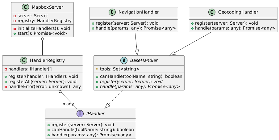
In mapbox-mcp-server, we use the following structure to manage the server's handlers:

  • src/server/handlers/base.ts: Base class for all handlers

  • src/server/registry.ts: Registry for all handlers

  • src/server/main.ts: Main entry point for the server

Each feature module follows this structure:

src/
├── types/          # Type definitions
├── schemas/        # Zod schemas for validation
├── tools/
│   ├── definitions/  # Tool definitions
│   └── handlers/     # Tool implementations
└── server/
    └── handlers/     # Handler classes

Class Diagram: mapbox-mcp-server-class-diagram

Process Diagram: mapbox-mcp-server-process-diagram

Error Handling

All tools implement comprehensive error handling:

  • Input validation errors

  • API request failures

  • Rate limit errors

  • Service-specific errors (e.g., no routes found, invalid coordinates)

License

This MCP server is licensed under the MIT License. This means you are free to use, modify, and distribute the software, subject to the terms and conditions of the MIT License. For more details, please see the LICENSE file in the project repository.


Available Tools

5 tools
mapbox_directionsC

Get navigation route between two points

ParametersJSON Schema
NameRequiredDescriptionDefault
coordinatesYesArray of coordinates
profileNoNavigation modedriving-traffic

TDQS

C2.9/5.0
Behavior2/5

Does the description disclose side effects, auth requirements, rate limits, or destructive behavior?

With no annotations provided, the description carries full burden for behavioral disclosure. While 'Get navigation route' implies a read-only operation, it doesn't address authentication requirements, rate limits, error conditions, response format, or whether this is a real-time vs. cached service. The description provides minimal behavioral context beyond the basic operation.

Agents need to know what a tool does to the world before calling it. Descriptions should go beyond structured annotations to explain consequences.

Conciseness5/5

Is the description appropriately sized, front-loaded, and free of redundancy?

The description is extremely concise at just 5 words, front-loading the core purpose without any wasted language. Every word earns its place in communicating the essential function.

Shorter descriptions cost fewer tokens and are easier for agents to parse. Every sentence should earn its place.

Completeness2/5

Given the tool's complexity, does the description cover enough for an agent to succeed on first attempt?

For a navigation API tool with no annotations and no output schema, the description is insufficient. It doesn't explain what a 'navigation route' includes (distance, duration, steps, geometry), error handling, authentication needs, or how results differ from sibling tools. The minimal description leaves too many contextual gaps for effective agent use.

Complex tools with many parameters or behaviors need more documentation. Simple tools need less. This dimension scales expectations accordingly.

Parameters3/5

Does the description clarify parameter syntax, constraints, interactions, or defaults beyond what the schema provides?

With 100% schema description coverage, the schema already documents both parameters thoroughly. The description adds no additional parameter semantics beyond what's in the schema - it doesn't explain coordinate ordering (origin to destination), minimum/maximum points, or practical usage of the profile parameter. This meets the baseline for high schema coverage.

Input schemas describe structure but not intent. Descriptions should explain non-obvious parameter relationships and valid value ranges.

Purpose4/5

Does the description clearly state what the tool does and how it differs from similar tools?

The description clearly states the verb ('Get') and resource ('navigation route between two points'), making the purpose immediately understandable. However, it doesn't differentiate this tool from its sibling 'mapbox_directions_by_places', which likely serves a similar purpose with different input parameters.

Agents choose between tools based on descriptions. A clear purpose with a specific verb and resource helps agents select the right tool.

Usage Guidelines2/5

Does the description explain when to use this tool, when not to, or what alternatives exist?

The description provides no guidance on when to use this tool versus alternatives. With sibling tools like 'mapbox_directions_by_places', 'mapbox_geocoding', and 'mapbox_matrix' available, there's no indication of when this coordinate-based directions tool is preferred over place-based or matrix alternatives.

Agents often have multiple tools that could apply. Explicit usage guidance like "use X instead of Y when Z" prevents misuse.

mapbox_directions_by_placesC

Get navigation route between multiple places using their names

ParametersJSON Schema
NameRequiredDescriptionDefault
placesYesArray of place names to route between
profileNoNavigation modedriving
languageNoLanguage for geocoding results

TDQS

C2.9/5.0
Behavior2/5

Does the description disclose side effects, auth requirements, rate limits, or destructive behavior?

With no annotations provided, the description carries full burden for behavioral disclosure but offers minimal information. It mentions geocoding ('using their names') which implies place name resolution, but doesn't disclose rate limits, authentication needs, error handling, or what the route output includes (e.g., distance, duration, geometry). For a navigation tool with zero annotation coverage, this is inadequate.

Agents need to know what a tool does to the world before calling it. Descriptions should go beyond structured annotations to explain consequences.

Conciseness5/5

Is the description appropriately sized, front-loaded, and free of redundancy?

The description is a single, efficient sentence that directly states the tool's purpose without unnecessary words. It's appropriately sized and front-loaded, with every word contributing to understanding the core functionality.

Shorter descriptions cost fewer tokens and are easier for agents to parse. Every sentence should earn its place.

Completeness2/5

Given the tool's complexity, does the description cover enough for an agent to succeed on first attempt?

For a navigation routing tool with no annotations and no output schema, the description is incomplete. It doesn't explain what the route output contains (e.g., waypoints, instructions, polyline), performance characteristics, or common failure modes. The geocoding aspect is hinted at but not elaborated, leaving significant gaps for agent understanding.

Complex tools with many parameters or behaviors need more documentation. Simple tools need less. This dimension scales expectations accordingly.

Parameters3/5

Does the description clarify parameter syntax, constraints, interactions, or defaults beyond what the schema provides?

Schema description coverage is 100%, so the schema fully documents all three parameters. The description adds no additional parameter semantics beyond implying that 'places' are resolved via geocoding. Since the schema does the heavy lifting, the baseline score of 3 is appropriate.

Input schemas describe structure but not intent. Descriptions should explain non-obvious parameter relationships and valid value ranges.

Purpose4/5

Does the description clearly state what the tool does and how it differs from similar tools?

The description clearly states the action ('Get navigation route') and resource ('between multiple places using their names'), making the purpose understandable. However, it doesn't explicitly differentiate from sibling tools like 'mapbox_directions' or 'mapbox_matrix_by_places', which likely have overlapping functionality with different input approaches.

Agents choose between tools based on descriptions. A clear purpose with a specific verb and resource helps agents select the right tool.

Usage Guidelines2/5

Does the description explain when to use this tool, when not to, or what alternatives exist?

The description provides no guidance on when to use this tool versus alternatives like 'mapbox_directions' (which might use coordinates instead of place names) or 'mapbox_matrix_by_places' (which might handle multiple routes). There's no mention of prerequisites, limitations, or typical use cases beyond the basic functionality.

Agents often have multiple tools that could apply. Explicit usage guidance like "use X instead of Y when Z" prevents misuse.

mapbox_geocodingC

Search for places and convert addresses into coordinates

ParametersJSON Schema
NameRequiredDescriptionDefault
searchTextYesThe search text to geocode
limitNoLimit the number of results
typesNoFilter results by feature types
languageNoLanguage of the search results
fuzzyMatchNoEnable/disable fuzzy matching

TDQS

C2.9/5.0
Behavior2/5

Does the description disclose side effects, auth requirements, rate limits, or destructive behavior?

With no annotations provided, the description carries the full burden of behavioral disclosure. It mentions the core functionality but omits critical details such as rate limits, authentication requirements, error handling, response format, or whether this is a read-only operation. For a geocoding tool with external API dependencies, this is a significant gap.

Agents need to know what a tool does to the world before calling it. Descriptions should go beyond structured annotations to explain consequences.

Conciseness5/5

Is the description appropriately sized, front-loaded, and free of redundancy?

The description is extremely concise (one sentence) and front-loaded with the core purpose. Every word earns its place, with no redundant or unnecessary information, making it easy for an agent to parse quickly.

Shorter descriptions cost fewer tokens and are easier for agents to parse. Every sentence should earn its place.

Completeness2/5

Given the tool's complexity, does the description cover enough for an agent to succeed on first attempt?

Given the tool's complexity (geocoding with 5 parameters), lack of annotations, and no output schema, the description is incomplete. It doesn't address behavioral aspects like API constraints, response structure, or error conditions, which are essential for proper tool invocation in a real-world context.

Complex tools with many parameters or behaviors need more documentation. Simple tools need less. This dimension scales expectations accordingly.

Parameters3/5

Does the description clarify parameter syntax, constraints, interactions, or defaults beyond what the schema provides?

The schema description coverage is 100%, providing clear documentation for all 5 parameters. The description adds no additional parameter semantics beyond what's in the schema, so it meets the baseline score of 3. It doesn't explain how parameters interact or provide usage examples.

Input schemas describe structure but not intent. Descriptions should explain non-obvious parameter relationships and valid value ranges.

Purpose4/5

Does the description clearly state what the tool does and how it differs from similar tools?

The description clearly states the tool's purpose with specific verbs ('Search for places' and 'convert addresses into coordinates') and identifies the resource (geographic data). It distinguishes from sibling tools by focusing on geocoding rather than directions or matrix calculations, though it doesn't explicitly name those alternatives.

Agents choose between tools based on descriptions. A clear purpose with a specific verb and resource helps agents select the right tool.

Usage Guidelines2/5

Does the description explain when to use this tool, when not to, or what alternatives exist?

The description provides no guidance on when to use this tool versus the sibling tools (mapbox_directions, mapbox_directions_by_places, mapbox_matrix, mapbox_matrix_by_places). It doesn't mention use cases, prerequisites, or exclusions, leaving the agent to infer usage from the purpose alone.

Agents often have multiple tools that could apply. Explicit usage guidance like "use X instead of Y when Z" prevents misuse.

mapbox_matrixC

Calculate travel time and distance matrices between coordinates

ParametersJSON Schema
NameRequiredDescriptionDefault
coordinatesYesArray of coordinates
profileNoNavigation modedriving
annotationsNoType of matrix to returnduration,distance
approachesNoApproaches to coordinates
bearingsNoBearings for coordinates
sourcesNoIndices of source coordinates
destinationsNoIndices of destination coordinates
fallback_speedNoSpeed for direct path calculation when no route exists
depart_atNoDeparture time in ISO 8601 format

TDQS

C2.9/5.0
Behavior2/5

Does the description disclose side effects, auth requirements, rate limits, or destructive behavior?

With no annotations provided, the description carries the full burden of behavioral disclosure. It mentions what the tool does but fails to describe critical behaviors such as rate limits, authentication requirements, error handling, or output format. For a tool with 9 parameters and no output schema, this leaves significant gaps in understanding its operation.

Agents need to know what a tool does to the world before calling it. Descriptions should go beyond structured annotations to explain consequences.

Conciseness5/5

Is the description appropriately sized, front-loaded, and free of redundancy?

The description is a single, efficient sentence that directly states the tool's function without unnecessary words. It's appropriately sized and front-loaded, making it easy to understand at a glance.

Shorter descriptions cost fewer tokens and are easier for agents to parse. Every sentence should earn its place.

Completeness2/5

Given the tool's complexity, does the description cover enough for an agent to succeed on first attempt?

Given the complexity (9 parameters, no annotations, no output schema), the description is insufficient. It doesn't explain the return values, error conditions, or practical usage scenarios. For a matrix calculation tool with multiple configuration options, more context is needed to guide effective use.

Complex tools with many parameters or behaviors need more documentation. Simple tools need less. This dimension scales expectations accordingly.

Parameters3/5

Does the description clarify parameter syntax, constraints, interactions, or defaults beyond what the schema provides?

Schema description coverage is 100%, so the schema already documents all parameters thoroughly. The description doesn't add any meaningful semantic context beyond what the schema provides, such as explaining relationships between parameters or typical use cases. The baseline score of 3 reflects adequate but minimal value addition.

Input schemas describe structure but not intent. Descriptions should explain non-obvious parameter relationships and valid value ranges.

Purpose4/5

Does the description clearly state what the tool does and how it differs from similar tools?

The description clearly states the verb ('calculate') and resource ('travel time and distance matrices between coordinates'), providing a specific purpose. However, it doesn't differentiate from sibling tools like 'mapbox_matrix_by_places', which likely serves a similar function with different input types.

Agents choose between tools based on descriptions. A clear purpose with a specific verb and resource helps agents select the right tool.

Usage Guidelines2/5

Does the description explain when to use this tool, when not to, or what alternatives exist?

No guidance is provided on when to use this tool versus alternatives like 'mapbox_matrix_by_places' or other sibling tools. The description lacks context about use cases, prerequisites, or exclusions, offering only a basic functional statement.

Agents often have multiple tools that could apply. Explicit usage guidance like "use X instead of Y when Z" prevents misuse.

mapbox_matrix_by_placesC

Calculate travel time and distance matrices between places using their names

ParametersJSON Schema
NameRequiredDescriptionDefault
placesYesArray of place names
profileNoNavigation modedriving
annotationsNoType of matrix to returnduration,distance
languageNoLanguage for geocoding results
sourcesNoIndices of source places
destinationsNoIndices of destination places
fallback_speedNoSpeed for direct path calculation when no route exists
depart_atNoDeparture time in ISO 8601 format

TDQS

C2.9/5.0
Behavior2/5

Does the description disclose side effects, auth requirements, rate limits, or destructive behavior?

With no annotations provided, the description carries the full burden of behavioral disclosure. It mentions what the tool does but doesn't describe important behavioral traits: whether it requires authentication, rate limits, what happens when place names are ambiguous, error handling, or the format of returned matrices. For a complex tool with 8 parameters, this is a significant gap.

Agents need to know what a tool does to the world before calling it. Descriptions should go beyond structured annotations to explain consequences.

Conciseness5/5

Is the description appropriately sized, front-loaded, and free of redundancy?

The description is a single, efficient sentence that clearly states the tool's core functionality. It's appropriately sized and front-loaded with the essential information. There's no wasted verbiage or unnecessary elaboration.

Shorter descriptions cost fewer tokens and are easier for agents to parse. Every sentence should earn its place.

Completeness2/5

Given the tool's complexity, does the description cover enough for an agent to succeed on first attempt?

For a complex matrix calculation tool with 8 parameters, no annotations, and no output schema, the description is insufficient. It doesn't explain what the output looks like (matrix format), doesn't mention authentication requirements, doesn't discuss rate limits or costs, and doesn't provide context about when this tool is appropriate versus alternatives. The description should do more given the tool's complexity.

Complex tools with many parameters or behaviors need more documentation. Simple tools need less. This dimension scales expectations accordingly.

Parameters3/5

Does the description clarify parameter syntax, constraints, interactions, or defaults beyond what the schema provides?

Schema description coverage is 100%, so the schema already documents all 8 parameters thoroughly. The description adds minimal value beyond the schema - it mentions 'using their names' which hints at the 'places' parameter, but doesn't provide additional context about parameter interactions or usage patterns. Baseline 3 is appropriate when the schema does the heavy lifting.

Input schemas describe structure but not intent. Descriptions should explain non-obvious parameter relationships and valid value ranges.

Purpose4/5

Does the description clearly state what the tool does and how it differs from similar tools?

The description clearly states the tool's purpose: 'Calculate travel time and distance matrices between places using their names.' It specifies the verb ('calculate'), resource ('travel time and distance matrices'), and method ('using their names'). However, it doesn't explicitly differentiate from sibling tools like 'mapbox_matrix' (which likely uses coordinates rather than place names).

Agents choose between tools based on descriptions. A clear purpose with a specific verb and resource helps agents select the right tool.

Usage Guidelines2/5

Does the description explain when to use this tool, when not to, or what alternatives exist?

The description provides no guidance on when to use this tool versus alternatives. It doesn't mention sibling tools like 'mapbox_matrix' (which might use coordinates instead of place names) or 'mapbox_directions_by_places' (which might provide route details rather than matrices). There's no context about appropriate use cases or exclusions.

Agents often have multiple tools that could apply. Explicit usage guidance like "use X instead of Y when Z" prevents misuse.

TDQS

B3.4/5.0
Disambiguation4/5

The tools are mostly distinct, with clear separation between directions, geocoding, and matrix calculations. However, there is some potential for confusion between mapbox_directions and mapbox_directions_by_places, as well as between mapbox_matrix and mapbox_matrix_by_places, since each pair serves similar purposes but with different input formats (coordinates vs. place names).

Naming Consistency5/5

All tool names follow a consistent pattern of 'mapbox_' prefix followed by a descriptive action (e.g., directions, geocoding, matrix) and optional qualifiers (e.g., by_places). This uniformity makes the tool set predictable and easy to understand.

Tool Count5/5

With 5 tools, the server is well-scoped for its mapping and navigation domain. Each tool addresses a specific functionality (routing, geocoding, matrix calculations), and the count is neither too sparse nor overwhelming, fitting typical use cases effectively.

Completeness4/5

The tool set covers core mapping operations like routing, geocoding, and travel time calculations, with variations for coordinates and place names. A minor gap is the lack of tools for map rendering or static map image generation, which might be expected in a mapping context, but the provided tools support essential workflows without dead ends.

Maintenance

ActivityInactive
ResponsivenessSyncing

Resources

Unclaimed servers have limited discoverability.

Looking for Admin?

If you are the server author, to access and configure the admin panel.

Related MCP Connectors

Related MCP Servers

Latest Blog Posts

MCP directory API

We provide all the information about MCP servers via our MCP API.

curl -X GET 'https://glama.ai/api/mcp/v1/servers/ngoiyaeric/mapbox-mcp-server'

If you have feedback or need assistance with the MCP directory API, please join our Discord server